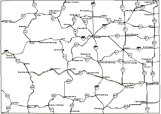
Welcome to Colorado-Mountains and much more.
The capital is Denver. - State motto is: Nothing without Providence.
Colorado is nicknamed the 'Centennial State.' It joined the Union in
1876, one hundred years after the Declaration of Independence had been signed. The terrain
in the south-eastern portion is very, very flat. Lamar proclaims to be -The history town
on the Santa Fe Trail.
'The Madonna of the Trail' monument is one of twelve such monuments, sponsored by the
Daughters of the American Revolution to mark the National Old Trails. Each of the twelve
Madonna monuments is placed in a different state of the Union. US Highway 50 is one of the
National Old Trails!
We visit Bent's Old Fort, a major stopping point on the Santa Fe Trail. Today's fort is a
very accurate reconstruction of how it appeared in 1845-46. American manufactured goods
traveled on the Santa Fe Trail from Independence to Santa Fe. Goods from Mexico and Navajo
origin traveled in the opposite direction. Bent's Old Fort was located on the Arkansas
River and served Indian tribes, pioneers, and independent mountain men.
(Ken Curtis who played Fetus on the TV show "Gunsmoke" was from Bent
County
and his father was sheriff of the county. John
Ford)
LA JUNTA was
once the la junta (HUNTA) -the junction- of the old Navajo and Santa Fe trails. The
Koshare Indian Kiva and Museum displays in
the round room an Indian method of constructing a large ceiling. The museum has a large
collection of oil paintings where the theme is Indian life and Southwestern territory.
www.visitlajunta.net
La Junta is the home of Doyle Davidson, 'the' promoter of Highway 50 travel and
preservation. While he chaired the National Highway 50 Federation, Doyle traveled this
route for 10 years logging about 60,000 miles per year. He calls Highway 50 -- Main Street
of America. While in La Junta you may want to stay at the KOA
Campground. They will treat you right if you tell them about Route50.com.
Downtown Pueblo has done some extensive renovation
and restoration. It's a clean downtown area. We admire the Spanish architecture with
American type of influence.
As we enter Fremont County, we are encircled on three sides by mountains. In
Ca�on City we visit the Holy Cross Abbey. This very beautiful monastery building was
constructed in Gothic style and completed in 1926. Approximately thirty Benedictine monks
still live at the sanctuary.
The Colorado Territory Prison Museum in Ca�on City was known as 'Hell Hole of the Old
West'.
There many attractions in and
around Ca�on City.
The Royal Gorge Suspension Bridge is the highest suspension bridge in the world, soaring
1,053 feet above the Arkansas River. We enjoy a picnic at the mountain ridge. The scenery
is breathtaking.
We drive along the Arkansas River as we enter the Big Horn Sheep Canyon. All along the
river are scenic stops where you can park to fish and take pictures. After driving 78
miles from Cannon City, we arrive in Salida, elevation 7,038 feet.
Internationally famous landscape fiber artists - Christo and
Jeanne-Claude are planning on
doing some of their work over the Arkansas River between Salida and Canon
City.
This unusual art work is planned to be displayed along the
Arkansas River.
For more information
The mountains surrounding Salida are called the 49ers. There are four huge mountains above 9,000 feet. Chaffee County is rich in mining and ghost town history. Many towns are completely gone, but one may still find some remnants. The ghost town of Turret is about fourteen miles from Salida. One should use a four-wheel drive when searching for ghost towns.
While in Salida, check out the Circle
R Motel. Tell Pam & Lee that I sent you.
After you had a restful night tell me how you liked their hospitality.
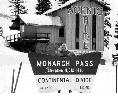
Monarch Crests is the Continental Divide, elevation 11,312 feet-that is over two miles up.
To the east is the Atlantic, to the west, the Pacific. What a beautiful sight! The air is
clean. We can almost touch the sky. You can view road conditions from a Web-Cam.
Descending to the west we reach Gunnison, elevation 7,703 ft. In less then an hour, we
dropped about 4,000 feet. There are plenty of motels in this town. Its character is
similar to Salida.
Welcome to Black Canyon of the
Gunnison National Park. Here you can experience one of the most incredible canyons in North America.
Highway 347 climbs 2,000 feet in five miles to the monument entrance. Spring is a
wonderful time to visit as snow may still highlight crooks and crevices. It brings
dangers, though. Watch for icy conditions on roads and trails. Some of the trails may
still have several feet of snow. The six-mile South Rim Drive leads to several overlooks
from which to view the Gunnison River 2,000 feet below. These cliff walls are made up of
rock that is 1.7 billion years old, some of the oldest rocks in North America.
(taken from
National Park Service recording)
Much of these rocks are composed of metamorphic rock
which is a result of volcanic debris but it is also composed of granite, quartz
and tungsten. While tungsten is a rare commodity and can very lucrative to
collect in order to make tungsten rings,
please keep in mind that collecting rock specimens within the National Park is
illegal.
After our canyon visit, we descend 2,000 feet to Montrose where we find
comfortable accommodations for the evening. The city has been a supply point since the
1880s. First came miners following the Uncompahgre River. Today, local outfitters serve
recreational interests in addition to the traditional ranching, farming and mining.
After passing through Delta, a town with great
history, we are on our way to Grand
Junction. The country gets very isolated and flat with few mountains on the side of
the road. There are no more houses, no more ranches, just a straight piece of road on
which cars travel. In its simplicity, its beauty lies in its magnitude, how large it is.
People who have never seen the West should come out and view this area of the country. We
are still about a mile high at this time, the air is perfect, clean, no pollution.
Route 50 reaches Grand Junction, Colorado, the place where the Colorado and Gunnison
Rivers meet. In Grand Junction, we visit the Colorado National Monument. The
monument is actually a state park.
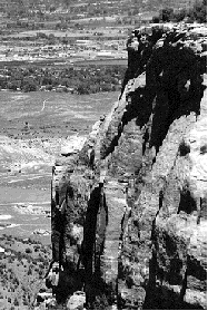
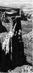
The drive into Colorado National Monument is very impressive. We enter through the East
Entrance where the elevation is 4,930 feet. A four-mile serpentine drive along the canyon
walls brings us to the top. Massive boulders on both sides of the road wait for the right
moment to tumble. Since they have waited for thousands of years, I hope they will stay in
place until we have passed. Rim Rock Drive offers 23 miles of breathtaking views, The road
winds along the rim and lets us enjoy panoramas of great rock sculptures, canyons and
distant valleys. At the highest point, we can admire from 6,640 feet the Colorado River
below.
We decided to camp high above the canyon. The sites are very spacious but they have no
electrical or septic hook-up. The bathrooms have only cold running water. As we lay down,
we could see the moon, the stars, and Junction City in the far distance. The canyons are
below. I can see the city, the interstate, but I hear no sounds from civilization-just
observe movements. It is very quiet.
We continue our journey west. Ahead of us are rolling hills and big canyon walls. No
additional settlements appear. This wilderness has its own beauty. A sign proclaims that
we are now leaving Colorful Colorado.
go back to US50, Coast to Coast

My book "US 50, Coast to Coast" guides you on this journey in greater
details.
To obtain information on ordering a copy of US 50 COAST to COAST,
click here